


Boucle l'Espignon, Spaeny,Teychené, et sémaphore

ego
User
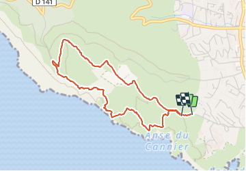

Length
4.6 km

Max alt
304 m

Uphill gradient
263 m
Km-Effort
8.1 km

Min alt
48 m

Downhill gradient
266 m
Boucle
Yes
Creation date :
2023-09-26 08:55:42.221
Updated on :
2023-09-26 12:09:42.314
1h48
Difficulty : Medium

FREE GPS app for hiking
 SityTrail
IGN / Geographical institutes
SityTrail Plus
The world is yours!
About
Trail Walking of 4.6 km to be discovered at Provence-Alpes-Côte d'Azur, Bouches-du-Rhône, La Ciotat. This trail is proposed by ego .
Positioning
Country:
France
Region :
Provence-Alpes-Côte d'Azur
Department/Province :
Bouches-du-Rhône
Municipality :
La Ciotat
Location:
Unknown
Start:(Dec)
Start:(UTM)
710534 ; 4783034 (31T) N.
Comments